Ukraine Conflict Update: as of 18 December 2023

DeTect specializes in delivery, integration and support of advanced, proven bird monitoring and mitigation systems (BMMS) for wind energy project developers, owners, operators and environmental consultants for bird and bat survey, mortality risk assessment, operational monitoring and real-time risk mitigation with over 800 systems delivered worldwide.
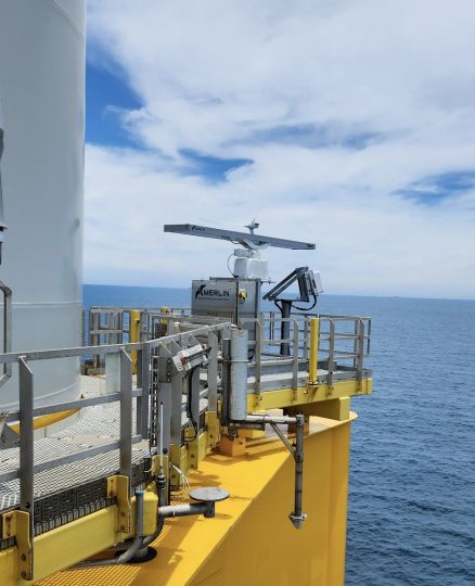
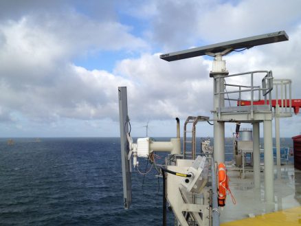
DeTect is the developer and manufacturer of the MERLIN Avian Radar System, the most advanced and proven bird & bat monitoring system available for windfarm project avian survey, risk assessment, monitoring and real-time risk mitigation with over 800 systems delivered worldwide. The MERLIN technology was originally developed for the US Air Force and NASA as a precision bird detection radar system to provide real-time information to controllers, pilots and managers to reduce bird-aircraft strike risk.
MERLIN™ technology is capable of collecting high quality data on bird activity at ranges of 3-8 miles around proposed wind farm sites. These data can be used to develop detailed pre-construction mortality risk projections and for operational mitigation.

With the MERLIN SCADA bird and bat mortality risk mitigation feature, the MERLIN system can be used at operating wind farms to function as an “early warning” system providing advance detection of bird & bat activity that presents mortality risk, automatically engaging response mitigation actions up to and including idling of turbines until the risk passes.
DeTect provides full operational and technical support to wind farm owners, developers, operators and consultants that includes system deployment, operation, user training, and data processing, analysis, reporting and QA/QC.
Staff specialists include highly knowledgeable radar ornithologists, avian biologists, engineers and statisticians that comprises the top team of experts in remote sensing of birds and bats in the world – with specific expertise in design, construction and operation of bird/wildlife detection systems for real-time aviation safety and environmental management.

Avian Monitoring on the Radar – Originally developed for the US Air Force and NASA as a precision bird detection radar system, DeTect’s Avian Radar technology can provide continuous monitoring of bird and bat activity at ranges of three to eight miles around wind farm sites. The company’s Senior Biologist, Jenny Davenport, explains more to PES.
Download the Interview > PES-W-3-23-Detect
MERLIN provides the most cost-effective, scientifically sound, and complete method for collection of high-quality, statistically superior data on bird and bat movements at proposed wind turbine project locations – for both on-shore and off-shore wind turbine installations.
MERLIN, originally developed for the demanding aviation safety application, is the most advanced and proven technology available for bird and bat surveys with over 40 systems operating at windfarms in the US, Canada, the UK, Europe, Africa and New Zealand.
Systems include solid-state Doppler radar technology with custom bird mode waveforms that were developed specifically for detection and tracking of birds and bats. Systems are also available with optional Frequency Diversity processing for enhanced detection in heavy ground and sea clutter.
Using state-of-the-art radar and computer techniques developed specifically for detecting and tracking the unique behavioral characteristics of birds and bats, MERLIN collects data continuously and automatically under a variety of conditions generating highly accurate, detailed datasets for analysis and for use in project decision-making and permitting.
MERLIN processes the radar signal in real-time with high update rates of 1-2 seconds providing live displays of bird activity location, flight paths, altitudes, sizes and other information to project biologists and windfarm operators. Multiple users can view the information display simultaneously as well as remotely control the system via LAN, satellite and WWAN (cellular) datalinks.
All system operational settings are accessible through password protected on-screen Graphical User Interfaces (GUIs) and changes can be made in real time during system operation. All system functions are remotely controllable including system shutdown and cold system restart.
MERLIN is fully automated for 24-7 unattended operation and includes an internal Health & Safety System (HSM) that continually runs diagnostics and provides audible, visual, text message and email alerts in the event of system issues such as loss of power or component failure.
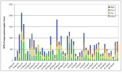
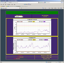
Data is also automatically archived to the internal MERLIN SQL server datasystem providing a permanent record for each project and to support detailed analysis, modeling and quantitative mortality risk assessment. MERLIN SQL has a built-in Data Reporter with a wide range of standard wind energy information and analyses such as passage rate, rotor swept zone percent, and flight patterns.
MERLIN Reporter includes two unique routines – MERLIN TrackPlot and MERLINChart that automate user analysis of activity by area and period. The system also supports custom user-developed queries and analysis in GIS and other third-party software. The data system storage capacity will retain several years of 24-7 data and can be easily expanded by addition of commercially available, low cost plug-and-play hard drives.
The MERLIN system is the most advanced technology for wind energy projects and offers significant benefits over conventional visual and manual radar ornithology avian survey techniques.
The MERLIN Avian Monitoring System is the most powerful tool available for assessment of proposed wind energy projects and generates high quality, detailed datasets that can be used to accurately determine the numbers of bird and bats transiting a proposed project site within the rotor swept areas under day, night and low visibility conditions.
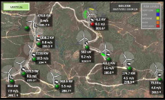
DeTect’s proprietary Data Reports program generates detailed datasets in both tabular and graphical formats quantifying the numbers of birds passing through the rotor swept area allowing precise calculation and determination of bird and bat mortality risk.
For operating windfarms, DeTect’s MERLIN SCADA (Supervisory Control and Data Acquisition) functionality allows the MERLIN system to operate as a real time bird and bat monitoring and risk mitigation system. The MERLIN SCADA software combined with an MERLIN Avian Radar System and other sensor data inputs including weather and visibility information delivers real-time radar-based curtailment or deterrence to prevent bird mortality while maximizing energy production.
DeTect’s MERLIN SCADA is the only proven bird and bat mortality risk technology in operational use at wind farms for protection of migratory birds, resident birds, raptors and bats.
MERLIN SCADA provides advance “early” warning (out to 3-8 miles) to windfarm managers and operators of approaching migratory or individual birds and bats under mortality risk conditions and manually or automatically implements responses up to and including idling of turbines. The system can operate autonomously and in all weather and visibility conditions, automatically idling individual, groups or all turbines when risk conditions are detected by the MERLIN system, applying pre-programmed ‘risk rule sets’, restarting the turbines when the risk has abated.
The MERLIN SCADA operating software is fully compatible with all wind farm turbines and SCADA systems and DeTect provides full development, integration, implementation and operational support which includes development of real-time remote operator interface displays.
In recognition of DeTect’s contribution to environmentally sustainable design engineering, MERLIN SCADA was awarded a Green Dot award in 2008. MERLIN SCADA has been operating successfully at windfarms since 2009 for migratory bird fall-out risk mitigation (SCADA-M), and since 2010 for raptor risk mitigation (SCADA-R) using DeTect’s Turbine Centric model to automatically idle individual turbines when a raptor approaches a turbine.
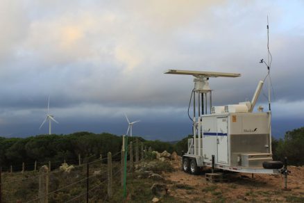
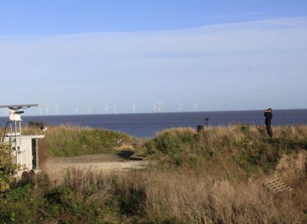
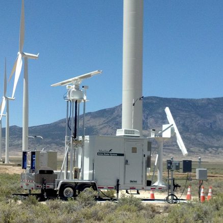
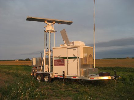
DeTect’s bird and bat radar systems are available as fully- mobile and skid-mounted, self-contained systems with on-board control cabin, power system, and include all hardware and software for bird and bat tracking, clutter suppression, and data recording. Custom configurations, including fully remote controlled offshore installations, can also be provided that incorporate additional sensors such as thermal cameras, bat detectors, insect detectors and vertical profilers.
Systems are available for short-term rental, long-term lease, lease-purchase, or for sale from DeTect, both with and without DeTect operators and DeTect provides complete technical support from survey through data analysis and a complete parts and labor warranty.
The U.S. Fish and Wildlife Service (FWS) Great Lakes Radar study
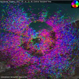
The U.S. Fish and Wildlife Service (FWS) has multiple years of MERLIN Avian Radar System data for the Great Lake Region collected with the two MERLIN units purchased in 2010. The two mobile units were used to conduct surveys to map activity for wind resource areas to support environmental protection and wind energy development for the Region. FWS studied bird and bat activity using avian radar and acoustic bat monitors starting in 2010 to accelerate protection and restoration and development efforts. Using the MERLIN Avian Radar, FWS was able to develop extensive data on where, at what altitude, and under what conditions birds and bats migrate. From the program, FWS, developed a Decision Support Tool (DST) designed to provide conservation managers with information on important habitat on the ground (i.e. stopover habitat) and in the air (i.e. airspace habitat) and to help guide and prioritize locations that would most benefit avian migrants and migratory and non-migratory bats.
Find out more here
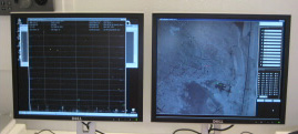
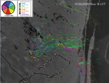
Images (right): A radar Trackplot, tracking peak spring migration northward along the shore of Lake Michigan + MERLIN unit
Please complete the enquiry form and a member of the DeTect team will contact you shortly.